


Dr. Sanjay Rana, PARSAN Overseas Pvt. Ltd. | Blog article draft
Some of the most important questions in a major project sit hundreds of metres below ground and spread across hundreds of square kilometres. Where does the aquifer run? How deep is the bedrock along the proposed alignment? Where are the conductive zones that point to mineralisation? Answering these questions one borehole or one survey line at a time is slow, expensive, and in rugged or inaccessible terrain, sometimes impossible.
Airborne geophysics flips that problem on its head. Instead of moving instruments across the ground point by point, the sensors fly – mounted on an aircraft, a helicopter, or increasingly a drone – and collect continuous subsurface data over vast areas in a fraction of the time. For regional groundwater studies, mineral exploration, and early-stage reconnaissance of large infrastructure corridors, it is one of the most powerful tools available.
This article explains what an airborne geophysical survey actually measures, where it adds the most value, and how it fits alongside ground-based investigation.
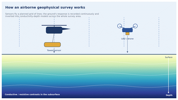
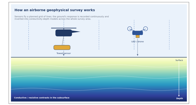
Figure 1. An airborne survey flies a planned grid of lines, recording the ground’s response and inverting it into conductivity-depth models across the whole area.
What is an airborne geophysical survey?
An airborne geophysical survey carries one or more geophysical sensors over a survey area along a planned grid of flight lines. As the platform flies, the instruments continuously record physical properties of the ground below – its electrical conductivity, magnetic character, natural radioactivity, or density. After acquisition, the raw measurements are processed and inverted into maps and depth models that reveal the subsurface structure across the whole survey block.
The key advantage is coverage. A ground crew might survey a few line-kilometres in a day; an airborne system can cover hundreds. That makes it possible to build a consistent, gap-free picture over an entire watershed, mineral belt, or project corridor, and then focus expensive ground investigation and drilling exactly where it matters.
Several methods can be flown, either on their own or together in a single combined survey.
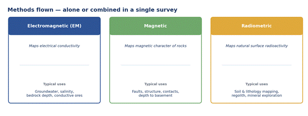
Figure 2. The three methods most commonly flown, and what each is typically used for.
Airborne electromagnetics (AEM)
Electromagnetic methods map the ground’s electrical conductivity (or its inverse, resistivity), which responds strongly to changes in water content, salinity, clay, and many ore minerals. A transmitter generates an electromagnetic field, and a receiver records the ground’s response; the depth and strength of that response are inverted into a conductivity-versus-depth model beneath every point along the flight line.
Two configurations are common. Time-domain (also called transient, or TEM/TDEM) systems pulse the field and listen to the decaying response, and generally reach greater depths. Frequency-domain systems transmit continuously at fixed frequencies. Helicopter-borne arrangements, where the sensor is towed beneath the aircraft, give high spatial detail; fixed-wing systems cover ground faster over very large regional blocks.
AEM is the workhorse for groundwater and aquifer mapping, salinity and saltwater-intrusion studies, depth-to-bedrock estimation, and conductive mineral targeting.
Airborne magnetics
Magnetic surveys measure tiny variations in the Earth’s magnetic field caused by differences in the magnetic properties of rocks. The resulting maps trace geological structure with remarkable clarity – faults, shear zones, dykes, contacts between rock types, and the depth to crystalline basement beneath sedimentary cover. Magnetics is fast, relatively inexpensive to add to a flight, and almost always flown as part of mineral-exploration and regional geological-mapping programmes.
Airborne radiometrics
Gamma-ray spectrometry records the natural radioactivity emitted by potassium, uranium, and thorium in the top few centimetres of soil and rock. Because different lithologies and weathering products carry distinct radiometric signatures, the data are excellent for surface geological and soil mapping, regolith characterisation, and certain kinds of mineral exploration. Radiometrics is commonly flown together with magnetics in a single pass.
Drone-based (UAV) geophysics
Uncrewed aerial vehicles have brought airborne methods within reach of much smaller sites. Drone-mounted magnetometers, and increasingly drone EM systems, fly low and slow, producing very high-resolution data over a few square kilometres at a lower mobilisation cost than a crewed aircraft. They are particularly useful for detailed follow-up of a target, for sites where terrain or safety rules out ground crews, and for surveys too small to justify a full aircraft.
Where airborne geophysics adds the most value
Airborne methods are not a replacement for detailed ground investigation – they are how you decide where detailed ground investigation should go. The strongest use cases share a common feature: a large or difficult area, and a need to prioritise before committing to expensive, slow ground work.
Regional groundwater and aquifer mapping. Airborne EM can map the geometry of aquifers, the depth and thickness of water-bearing layers, freshwater–saline boundaries, and recharge zones across an entire basin. In arid and data-poor regions, this is often the only practical way to plan a groundwater development programme before drilling.
Mineral exploration. A combined magnetic, radiometric, and electromagnetic survey can cover a whole licence block, highlight structural controls and conductive or magnetic anomalies, and generate a ranked set of drill targets – turning a blank map into a focused exploration plan.
Large infrastructure corridors. For long, linear projects – highways, railways, canals, transmission lines, pipelines – airborne surveys provide rapid reconnaissance of the geology, depth to rock, and problem zones (soft ground, buried channels, weak or conductive horizons) along the route, well before detailed alignment surveys begin.
Difficult and inaccessible terrain. Mountains, dense forest, marshland, desert, and security-sensitive areas can stop a ground crew entirely. From the air, a consistent dataset can be collected over all of it.
Environmental and hazard studies. Conductivity mapping helps trace contamination, characterise old mine workings and tailings, and map saline intrusion over large areas quickly.
The recurring theme is leverage. By spending on a fast, non-invasive aerial survey first, a project can cut the number of boreholes needed, place each one far more intelligently, and avoid the cost of drilling blind across ground that the airborne data has already shown to be uniform.
How an airborne survey comes together
A well-run survey is as much about design and interpretation as about the flying itself.
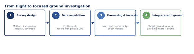
Figure 3. A typical airborne workflow – broad coverage from the air feeds focused, high-confidence work on the ground.
It begins with survey design: choosing the method or combination of methods, the line spacing and orientation, and the flying height needed to achieve the target depth and resolution. Tighter line spacing yields more detail but costs more, so the design is matched to the project’s objectives.
During acquisition, the platform flies the planned grid while precise positioning records exactly where each measurement was taken. Modern systems log enormous volumes of high-quality data on every pass.
Processing and inversion then convert the raw signals into usable products: conductivity-depth sections beneath each line, magnetic and radiometric maps, and three-dimensional models of the survey block. This stage is where experience matters most – the same raw data can support good or poor conclusions depending on how carefully it is processed and interpreted.
Finally, the airborne results are integrated with ground geophysics and drilling. The aerial survey identifies and prioritises targets; focused ground methods and selectively placed boreholes then confirm and refine them. The two scales work together – broad coverage from the air, high-confidence detail on the ground.
Understanding the limits
Airborne geophysics trades some resolution for enormous coverage, and it is important to plan around that trade-off. Aerial data is generally lower in resolution than a dedicated ground survey over the same spot, and the depth of investigation depends on the system and method chosen. Results always benefit from ground-truthing – a small number of well-placed boreholes or ground surveys to calibrate the interpretation. Surveys also require airspace and flying permissions, and for very small areas a ground or drone survey is usually more economical than mobilising a crewed aircraft.
None of this diminishes the method’s value. It simply means airborne geophysics works best as the first, wide-angle stage of an integrated investigation – not as a standalone answer.
The bottom line
When a project needs to understand the subsurface over a large or hard-to-reach area, airborne geophysics is often the fastest and most cost-effective place to start. It turns a daunting, expensive ground-investigation problem into a focused one: map broadly from the air, interpret carefully, and then commit ground resources only where the data tells you to.
PARSAN offers airborne geophysical surveys – including electromagnetic, magnetic, and radiometric methods – alongside its full range of ground-based techniques, so the aerial reconnaissance and the detailed follow-up are planned together as one coherent investigation.
Planning a groundwater, mineral, or large infrastructure project that could benefit from airborne coverage? Get in touch with our team to discuss the right survey approach for your site.
Publishing notes for the developer (remove before posting)
- Suggested URL slug: /airborne-geophysical-survey-india
- Meta title: Airborne Geophysical Surveys in India | PARSAN
- Meta description: Airborne geophysical surveys map groundwater, minerals, and large project corridors from the air – fast, non-invasive, and over vast areas. Learn how aerial EM, magnetic, and radiometric methods work.
- Primary keyword: airborne geophysical survey India
- Secondary keywords: drone geophysics, transient electromagnetic survey, airborne EM groundwater, aerial magnetic survey, mineral exploration geophysics
- Internal links to add: Airborne Geophysics service page; Water Resources / groundwater page; Mining Geophysics page; Techniques pages (Electromagnetic Surveys, Gravity & Magnetic Surveys).
- Images: Figures 1–3 are original illustrations supplied with this document and are safe to publish. They can be replaced with PARSAN’s own project photos (e.g. an aircraft/drone with a sensor, or a real conductivity-depth section) where available.
