


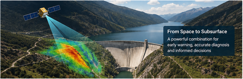
Figure 1. Conceptual view of satellite InSAR monitoring around a dam and reservoir. The value of the approach lies in detecting subtle surface movement over a wide area and then directing detailed investigation to the zones that matter.
A dam may appear completely normal while important changes are already developing. Small deformations can accumulate slowly. Reservoir rim slopes can move by millimetres before distress becomes obvious. Seepage can follow concealed pathways through foundations, abutments or embankments. Weak, fractured, saturated or deteriorated zones may remain invisible from the surface. The challenge in dam safety is therefore not simply to inspect what can be seen, but to detect change early and understand what is causing it.
This is where the combination of satellite InSAR and engineering geophysics becomes particularly powerful. InSAR provides a wide-area view of deformation at the ground surface. Geophysics investigates the physical conditions below the surface. Used together, the two approaches can move an investigation from observation to diagnosis: first identify where something is changing, then investigate why.
The key principle is simple: InSAR sees movement from above. Geophysics investigates the causes from below.
1. Why Dam Safety Needs Both Perspectives
Dams and reservoirs are complex systems. Their behaviour reflects the interaction of the dam body, foundation, abutments, reservoir loading, groundwater, geology, drainage systems, seasonal conditions and the surrounding slopes. A change observed at the surface is therefore only one part of the story.
Conventional dam safety instrumentation remains essential. Survey monuments, GNSS, pendulums, piezometers, uplift-pressure cells, seepage measurements, extensometers and other instruments provide direct and often high-quality information at selected locations. Their limitation is spatial coverage: they tell us what is happening where instruments exist. Visual inspection has a similar limitation because many important processes begin beneath the surface or away from routinely inspected points.
InSAR adds a spatial layer. It can screen a dam, abutments, downstream areas, reservoir margins and adjoining slopes repeatedly from space. This helps identify patterns, trends and zones that deserve closer attention. However, deformation alone does not reveal the cause. A moving slope may be responding to groundwater, rock structure, weathering, reservoir level changes or a combination of processes. Settlement on an embankment may reflect consolidation rather than distress. A deformation anomaly therefore needs engineering context.
Geophysics provides that context by imaging contrasts in subsurface physical properties. Electrical, seismic, electromagnetic and potential-field methods can be selected to investigate specific questions such as saturation, seepage, weak zones, fractures, voids, rockhead variation, material deterioration or foundation conditions. The most defensible result comes from integrating these measurements with geology, instrumentation, drilling and engineering observations.
2. What InSAR Actually Measures
Interferometric Synthetic Aperture Radar (InSAR) compares radar observations acquired from satellites at different times. Changes in radar phase are used to estimate changes in the distance between the satellite and the ground. Instead of obtaining displacement at only a few survey monuments, the technique can produce dense spatial information over large areas.
For dam and reservoir applications, time-series approaches such as Persistent Scatterer Interferometry (PSI) and Small Baseline Subset (SBAS) processing are particularly useful because the objective is usually not a single before-and-after image, but a deformation history. Published dam studies have demonstrated the ability of Sentinel-1 and other SAR data to map spatial patterns of dam settlement and reservoir-area deformation and to compare those patterns with ground observations and reservoir levels.
What InSAR can contribute:
- Wide-area screening of the dam body, abutments, downstream terrain and reservoir rim slopes.
- Time-series information showing whether an observed zone is stable, seasonal, accelerating or progressively deforming.
- Retrospective analysis where suitable historical satellite archives exist, allowing the current condition to be viewed in the context of past behaviour.
- Remote monitoring of difficult or inaccessible terrain without placing instruments at every location.
- Prioritisation of areas for field inspection, instrumentation, drilling and geophysical investigation.
Important limitation: InSAR is not a direct three-dimensional displacement measurement. A satellite fundamentally measures motion along its line of sight. Viewing geometry, slope orientation, vegetation, changing surface conditions, atmospheric effects, temporal decorrelation and water surfaces can all affect what can be measured. Ascending and descending geometries, ground control and engineering interpretation may be needed to separate or better understand displacement components. Therefore, an InSAR map should not be treated as a self-contained diagnosis of structural safety.
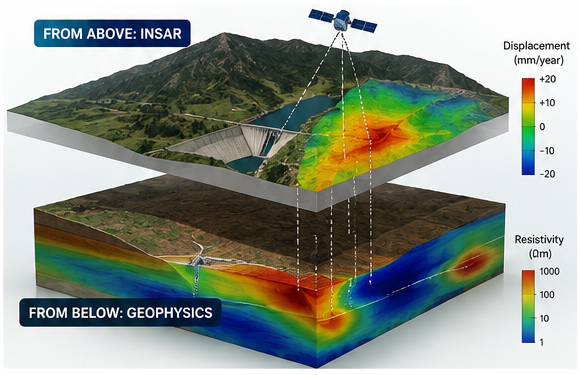
Figure 2. Conceptual integration: surface deformation detected from above is linked with a subsurface geophysical model below. The objective is not to force a one-to-one correlation, but to use each dataset to test and refine the interpretation of the other.
3. What Geophysics Adds Below the Surface
Engineering geophysics measures variations in physical properties such as electrical resistivity, seismic velocity, density, magnetic susceptibility and naturally generated electrical potential. These properties are influenced by geology, porosity, saturation, fractures, cavities, weathering, material condition and fluid movement. This makes geophysics particularly useful when the engineering question involves something that cannot be seen directly.
Electrical Resistivity Imaging (ERI / ERT)
Electrical resistivity imaging is often one of the primary methods for investigating embankment and masonry dams, foundations and abutments. Relative resistivity variations can help delineate zones of differing saturation, material composition, weathering or fracturing. In seepage studies, conductive anomalies may be important, but resistivity is not a seepage meter: clay-rich material, mineralisation and other factors can also produce low resistivity. Interpretation must therefore be comparative and integrated with geology, SP, piezometric information or other evidence.
Self Potential (SP)
SP is a passive electrical method that can respond to electrokinetic potentials associated with groundwater movement. It has a long history in seepage investigations and can complement resistivity particularly well. A coincident resistivity and SP anomaly may provide stronger evidence for a hydraulically active zone than either dataset alone, but cultural electrical noise and site conditions must be considered.
Seismic Refraction, SRT, MASW and ReMi
Seismic methods respond mainly to elastic properties. Refraction and seismic refraction tomography can help define velocity structure, depth to competent material, weathered or weak zones and foundation variability. MASW and ReMi provide shear-wave velocity information that can support assessment of stiffness and material condition. Their role is different from electrical methods, which is why combining seismic and electrical information can be valuable.
Seismic Tomography
Crosshole, cross-face and gallery-to-crest tomography can provide high-resolution velocity imaging across selected planes. This is particularly valuable after broader surface investigations have identified a zone that requires detailed diagnosis. Tomography should therefore be targeted rather than used indiscriminately, because it describes the investigated plane rather than the entire dam volume.
Ground Penetrating Radar (GPR)
GPR can be valuable for near-surface structural investigations, concrete elements, spillways and selected dam components where electromagnetic penetration is adequate. It can identify interfaces, reinforcement, void-related responses and other shallow anomalies. Penetration and resolution depend strongly on antenna frequency and material conductivity.
Microgravity and Other Methods
Where the engineering problem involves a density deficit such as a suspected cavity or significant material loss, microgravity can provide useful complementary evidence. Magnetic, electromagnetic, borehole and other specialised methods may also have roles depending on the target. Method selection must always begin with the engineering question, not with the instrument that happens to be available.
4. Why the Integration Is More Powerful Than Either Method Alone
The real opportunity is not simply to place an InSAR map beside a geophysical section. Integration should change the investigation strategy.
1. Establish the deformation picture – Analyse InSAR time series together with existing survey and instrumentation data. Identify stable zones, seasonal behaviour, persistent trends and areas of unusual or accelerating movement.
2. Develop engineering hypotheses – Ask what mechanisms could plausibly create the observed pattern: reservoir loading, slope movement, seepage, foundation settlement, weak rock, internal erosion, abutment movement or another process.
3. Design targeted geophysics – Select methods, profile locations, orientations and investigation depths specifically to test those hypotheses. Do not survey uniformly simply because a technique is available.
4. Correlate with ground truth – Integrate geology, boreholes, piezometers, seepage records, reservoir level, construction history, maintenance records and visual observations.
5. Refine the risk model – Use the combined evidence to distinguish benign or explainable deformation from zones that require additional investigation, instrumentation, drilling, remediation or closer monitoring.
6. Monitor change over time – Repeat satellite analysis and, where useful, selected geophysical measurements. Changes relative to a baseline can be more informative than isolated absolute values.
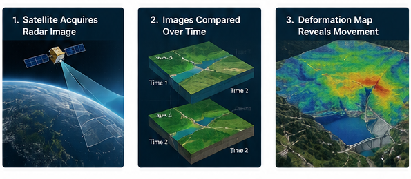
Figure 3. A practical workflow: wide-area satellite screening guides focused field investigation, which then supports engineering interpretation and decisions.
5. Where This Integrated Approach Can Add the Most Value
- Dam body deformation: Long-term settlement or differential movement of embankment and rockfill dams; deformation trends on concrete structures where radar coherence is adequate.
- Abutment and foundation behaviour: Detection of surface movement around abutments followed by geophysical investigation of fractured, weathered, saturated or structurally weak zones.
- Reservoir rim stability: Screening long reservoir margins and mountain slopes for slow-moving deformation, followed by targeted geophysics across the most significant zones.
- Seepage and internal erosion investigations: Using geophysics to investigate saturation and flow-related anomalies, especially where InSAR or ground observations indicate settlement or movement that may be hydrologically linked.
- Hydropower and pumped storage projects: Monitoring steep slopes, upper and lower reservoir rims, dam structures and large project areas where wide-area surveillance is difficult using ground instrumentation alone.
- Tailings and water-retaining structures: Screening embankments and surrounding ground for deformation and then investigating the subsurface conditions where movement patterns require explanation.
- Post-event assessment: After major rainfall, reservoir level changes, earthquakes or other events, satellite deformation analysis can help identify where conditions changed and guide targeted field investigation.
6. A Particularly Important Application: Reservoir Rim and Landslide Risk
Reservoir safety is not limited to the dam body. In mountainous terrain, unstable slopes around the reservoir can create major operational and safety concerns. The area to be monitored can extend for many kilometres, making dense ground instrumentation impractical. This is one of the strongest use cases for satellite InSAR: broad screening can highlight deforming slopes and help determine whether movement is localised or part of a larger pattern.
Once a moving slope is identified, the engineering questions become subsurface questions. Where is the likely shear zone? How deep is the weathered or loosened material? Is groundwater or reservoir infiltration influencing the movement? Is competent bedrock shallow or deep? Is the movement controlled by a fault, lithological contact or weak horizon? These are precisely the types of questions for which targeted ERI, seismic methods, passive seismic, borehole measurements and other geophysical techniques can add value.
The result is a much more efficient investigation. Instead of placing geophysical lines or boreholes arbitrarily across kilometres of terrain, satellite information can help focus resources on the zones that deserve detailed attention.
7. What This Approach Should Not Be Used For
Every powerful technology can be misused if its limitations are ignored. Several cautions are important:
- An InSAR deformation anomaly is not automatically evidence of dam distress or impending failure.
- Absence of a clear InSAR signal does not prove that there is no problem. Vegetation, geometry, decorrelation or a deformation direction poorly aligned with the satellite line of sight can reduce sensitivity.
- A resistivity anomaly is not automatically a seepage path. Electrical properties are non-unique and must be interpreted in geological and hydrological context.
- Geophysics should not be expected to replace boreholes or instrumentation. Its strongest role is to reduce uncertainty, improve spatial coverage and make intrusive investigation more intelligent.
- One geophysical method should rarely be expected to answer every dam-safety question. Multiple methods are often needed because different physical properties respond to different subsurface conditions.
- Absolute thresholds should be used cautiously. In many dam-health applications, spatial contrasts and changes over time are more defensible than simplistic universal cut-off values.
8. Building a Baseline: The Most Underused Opportunity
One of the most valuable steps in dam health assessment is to establish a baseline before a problem becomes urgent. For a new dam, the ideal time is soon after construction and initial reservoir filling. For an existing dam without baseline geophysical data, the practical answer is simple: the best time to establish the baseline is now.
A baseline changes the nature of future interpretation. Rather than asking whether a particular resistivity or velocity value is inherently “good” or “bad”, engineers can ask whether the physical properties have changed, where they have changed, how rapidly the change is developing and whether the change correlates with reservoir level, seepage, deformation or other indicators. The same principle applies to satellite deformation time series: trend and acceleration are often more informative than a single snapshot.
9. From Data Collection to Risk-Based Decision Making
The objective of advanced monitoring is not to produce more colourful maps. It is to support better decisions. A useful integrated programme should ultimately help answer questions such as:
- Which parts of the dam, abutments or reservoir rim are stable, and which are changing?
- Is the observed movement consistent with expected behaviour, or does it merit further investigation?
- Which subsurface mechanisms are most plausible?
- Where should boreholes, piezometers, inclinometers or other instruments be placed?
- Where should remediation or drainage measures be considered?
- Which zones should be monitored more frequently?
- How can the effectiveness of remedial measures be verified over time?
When these questions drive the survey design, InSAR and geophysics become part of an engineering decision framework rather than isolated technologies.
10. The Future: A Layered Digital Health Record for Dams
The direction of dam safety is toward integrated, time-dependent datasets. Satellite observations, ground instrumentation, geophysical models, borehole logs, reservoir levels, seepage records, inspection findings, LiDAR, drone surveys and engineering drawings can increasingly be brought into common 3D and GIS environments.
This makes it possible to move from periodic isolated surveys toward a digital health record of the asset. InSAR supplies repeated spatial deformation information. Geophysics contributes subsurface structure and condition. Instrumentation supplies continuous measurements at critical points. Geology and engineering history provide the interpretive framework. Each dataset has limitations, but together they can provide a much stronger basis for risk management than any one source alone.
The Bottom Line
InSAR and engineering geophysics answer different questions, and that is exactly why they work so well together. InSAR can reveal where the surface is moving across a dam and its wider environment. Geophysics can investigate the hidden conditions that may be responsible. When both are integrated with geology, instrumentation and engineering judgement, owners gain a more complete picture of asset behaviour.
The goal is not to replace conventional dam safety practice. It is to make it more intelligent: detect earlier, investigate smarter, drill more selectively, monitor the right places and intervene with greater confidence.
For dams and reservoirs operating in complex geological settings, the combination of a view from space and a diagnosis from below offers a powerful route from uncertainty to understanding – and from reactive investigation to proactive risk management.
References and Further Reading
- USGS. InSAR – Satellite-based technique captures overall deformation picture. U.S. Geological Survey Volcano Hazards Program.
- USGS. Monitoring Ground Deformation from Space. Fact Sheet 2005-3025.
- Minsley, B.J., Burton, B.L., Ikard, S., and Powers, M.H. (2010). Geophysical Investigations at Hidden Dam, Raymond, California: Summary of Fieldwork and Data Analysis. U.S. Geological Survey Open-File Report 2010-1013.
- Minsley, B.J., Burton, B.L., Ikard, S., and Powers, M.H. Hydrogeophysical investigations at Hidden Dam, Raymond, California. Journal of Environmental & Engineering Geophysics.
- Published case studies on PS-InSAR and SBAS-InSAR deformation monitoring of reservoir dams, including Banqiao, Xiaolangdi and Mosul dams.
Publishing Notes for Website Team
- Suggested URL slug: /insar-geophysics-dam-safety
- Meta title: InSAR and Geophysics for Dam Safety | PARSAN
- Meta description: Learn how satellite InSAR and engineering geophysics can be integrated to detect surface deformation, investigate subsurface causes, and improve dam and reservoir risk management.
- Primary keyword: InSAR and geophysics for dam safety
- Secondary keywords: dam deformation monitoring, satellite InSAR dam monitoring, dam geophysics, reservoir slope monitoring, seepage investigation, dam safety geophysics
- Suggested internal links: Non-Destructive Techniques for Inspecting Dams; Geophysical Techniques for Landslide Detection and Monitoring; Electrical Resistivity Imaging; Seismic Tomography; Passive Seismic Tomography; MASW; Ground Penetrating Radar.
