
Airborne Geophysical Service Provider
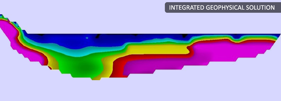
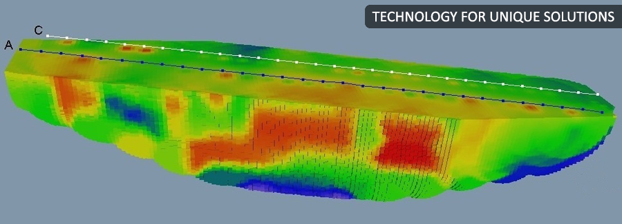
Back to ServicesParsan in association with SkyTEM Surveys ApS of Denmark is provider of airborne geophysical surveys offering the acquisition and advanced processing of transient electromagnetic (TEM), magnetic and radiometric data. We began as a breakthrough technology with the unique dual-moment capability to map both shallow and deep geology, concurrently and in high resolution. We remain totally involved in improving how the world maps the subsurface. We offer a choice of systems, each with a focus on the depth and resolution requirements of the mineral , energy, engineering and water sectors. Our deliverables include a diverse range of map products and visualizations such as 3D images and inversions within 48 hours.
Airborne Geophysical Survey
We do airborne geophysical survey and distinguish ourselves by :
Fast Survey Completion
- Acquisition of up to 1,000 line kilometres per day
- Robust system for challenging weather and terrain conditions
- Rare reflights required due to system engineering and survey planning
- Professional and competent field staff
Instant Data Turnover
- Data QC performed in the field as data is acquired
- Preliminary data and inversion delivered within 48 hours
- Allowing decision on in-fills to be made during the survey
High-quality Accurate Data
- Multi Moment maps near surface in high resolution concurrently with accurate measurements to depth
- Depth of penetration can be customized to suit the geology and target
- Meeting with the client to present and discuss final results
- Advanced processing options
The application areas for our airborne geophysics include:
Mineral Exploration
Airborne geophysical data can provide valuable input in mineral exploration for identification of likely drill targets but acquiring geophysical data can be an expensive exercise. It is vitally important to retrieve as much information as possible from the data to enhance the likelihood of exploration success. This century has witnessed the influence of knowledge to shape economies and corporations. To plan and operate more efficiently and effectively, exploration companies must take advantage of recently introduced innovative and advanced technology specifically engineered to quickly collect high quality data from which high value information can be extracted. It is also important in the 21st century to develop resources in environmentally, socially, and economically sustainable ways.
The knowledge economy can be regarded as the latest stage of development in global economic restructuring and is marked by upheavals in technological innovations. Mineral exploration companies must rely on intellectual capabilities as well as on physical inputs or natural resources and it is imperative they move into the knowledge based economy to succeed and compete globally. Exploration companies must look beyond dated traditional methods and take advantage of new products and processes developed by the research community. This is where SkyTEM, an innovative and technologically advanced airborne geophysical system, comes from. Developed by scientists, geophysicists and engineers, SkyTEM is designed to satisfy the growing knowledge and financial needs of the exploration community.
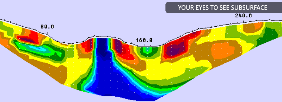
The SkyTEM method is applied globally for mineral exploration. As the only system capable of operating in dual transmitter modes SkyTEM delivers accurate near surface data together with data to depths up to 500 m. The system discriminates between weak geological contrasts giving a more complete and accurate interpretation of geology while increasing confidence in modeling deeper geological structure. Other advantages for resource exploration are:
- Extremely high signal to noise ratio and late time gates for enhanced data quality at depth.
- Fast turn-off time and early time data for resolving near surface layers as well as more resistive layers.
- Elimination of signal drift and a one-time calibration procedure so data manipulation is greatly reduced and inversions can be delivered within 2 days of acquisition.
- All sensors mounted on the rigid carrier frame ensuring all measurements are recorded close to the ground.
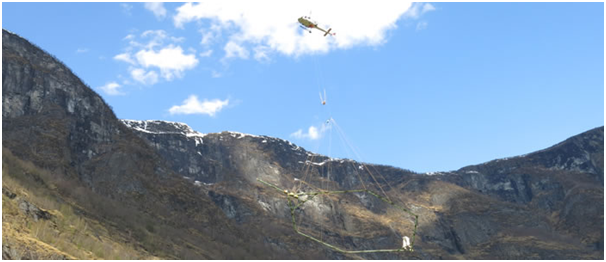
- No operator required in the helicopter reducing weight, fuel consumption and risk.
- No STC is required for quick installation in a variety of helicopters.
Water & Environment
The ability to reveal the availability and movement of water is a huge asset for countries and regions wanting to manage resources and respond to natural disasters.
The SkyTEM method, developed initially to identify and characterize aquifers, is widely accepted globally as the best technique for mapping water resources. Distinct from conventional airborne TDEM systems designed as single purpose sensors that push through the top few hundred metres to detect “bumps” or strong mineral contrasts, SkyTEM is capable of mapping subtle changes between sand, clay, silt, gravel, and tills that define the location and potential vulnerability of aquifers. The Danish Ministry of Environment has to date mapped over one third of the country’s aquifers with SkyTEM. Hydrogeology divisions of governments worldwide routinely select SkyTEM technology over all others to map their water resources.
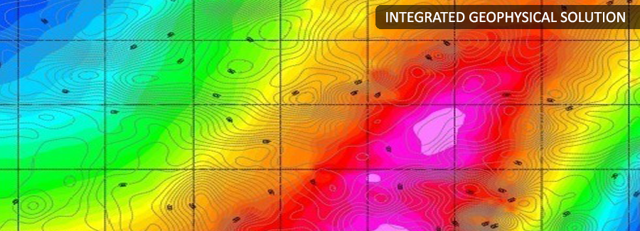
SkyTEM technology offers digital data that is used for creating detailed 3D geological representations of the subsurface down to 500 metres. These representations can be used for a variety of different applications and is a vital factor for setting up reliable and usable hydrological models in respect to sustainable Water management. SkyTEM Surveys has surveyed around 35% of Denmark’s total area for the purpose of groundwater protection and management.
Geotechnical Engineering
The application of airborne geophysics to provide solutions for engineering problems is increasing quickly. The SkyTEM method delivers accurate, high resolution, precisely positioned measurements giving scientists and engineers a better understanding of geology, hydrology, and natural and manmade hazards. SkyTEM projects include pre-construction engineering for pipelines, tunnels, harbours, mine site infrastructure, slope stability studies, overburden thickness determination, identification of fractures and faults and location of aggregate deposits and water resources.
SkyTEM is of high value to engineers as it provides a multi-sensor platform that collects various types of data concurrently, including:
- Electromagnetics – from near surface to depth and configurable for various geological settings, targets, depths and data requirements
- Magnetics – for mapping magnetic anomalies, fractures & faulting and man-made buried metallic objects
- GRS – measurement of radio-elements and detection of dangerous materials
- GPS – for positional accuracy
- Laser Altimeter- for accuracy in processing and delivery of digital elevation models
- Video Camera – for a record and review of ground features
Various types of data presentations and final products are available including inversions and 3D products.
Time is money and helicopter-borne surveys are an effective means of reducing the time and cost associated with gaining land access and permission for drilling. Integrated with ground-based measurements and a drilling program, airborne EM conductivity results provide a more complete understanding of ground characteristics.
Oil & Gas
SkyTEM is recognized globally as the best technology for mapping aquifers. Now the oil and gas sector is taking advantage these enhanced resolution systems for their ability to accurately map subtle changes in lateral geology and for the reliable inputs they deliver for detailed interpretation – from the very near surface to depth.
SkyTEM data is used to map shallow gas reservoirs, fresh, saline and acidic groundwater and to characterize deeper buried pathways such as pleistocene channels, paleovalleys, paleochannels and incised or glacial fluvial valleys. SkyTEM’s Dual Moment capability makes it possible to map these formations at varying depths concurrently with near surface targets, such as aggregates, that can be of geotechnical interest and potential engineering value.
SkyTEM data is particularly valuable to the oil and gas sector because:
- SkyTEM data has been shown to correlate closely to seismic data. Overburden thickness can be determined and the data can be used in advance of seismic and MT surveys for static corrections. A common static correction is a weathering correction that compensates for a layer of low seismic velocity material near the surface of the earth.
- The thickness, distribution of, and depth to shale cap rock, basement topography, and lateral and vertical delineation of oil sand units can be mapped so that strategic drill holes can be targeted with greater confidence. Bedrock rippability can also be determined.
- Fractures in the earth can be identified as well as clay caps in the near surface that trap gas and water beneath. Steam migration can also be monitored.
- SkyTEM data assists in the identification of higher potential drill targets compared with drilling deep expensive holes based on limited geological knowledge. A 4” bore hole represents approximately 1/ millionth of an acre whereas an airborne survey provides total coverage.
- SkyTEM data can be processed and preliminary results delivered within 48 hours. Targets of interest can be identified and more thorough mapping can be performed while the helicopter and crew are still on site.
